Sub-Saharan Africa

Sub-Saharan Africa

Case study: Sub-Saharan Africa electrification planning


Problem:

In the face of rural electrification challenges in Sub-Saharan Africa (SSA), the World Bank needed a reliable GIS-based model that would enable a rapid analysis of electrification strategies across 46 countries in SSA. The key was identifying the most efficient way to connect off-grid buildings with energy sources, balancing between extending the existing grid, building isolated mini-grids, and employing solar home systems in the least populated areas.

Solution:

VIA, with over 20 years of experience in GIS modeling, employed illustreets’ innovative, low-code spatial analytics, and reporting platform. Utilizing the software’ robust mapping and data analysis capabilities, VIA was able to run large-scale spatial analyses and visualizations at speed and scale.

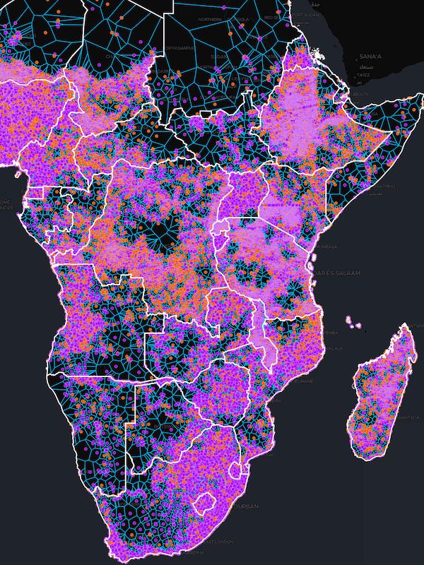
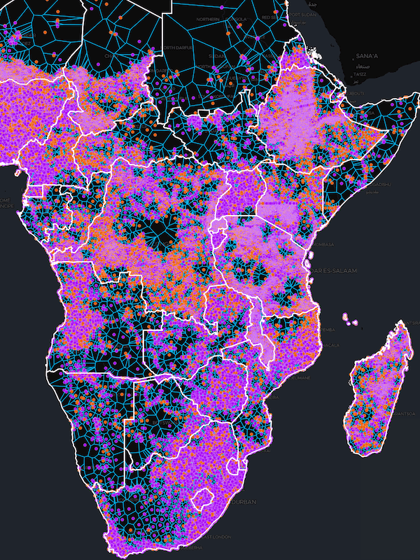
This enabled them to import and use High-Resolution Settlement Layer (HRSL) data, representing 102.7 million buildings across SSA, to determine potential electrification strategies. The analysis employed the concept of “Critical Distance”, a measure used to decide which households should be connected into grids and which should be served by isolated solar home systems.

They used the mathematical concept of a minimum spanning tree, enabling them to connect all off-grid buildings with the least length of cable possible, optimizing resources and costs.

Results:

With the help of illustreets, VIA rapidly produced detailed analysis results for 46 SSA countries. They estimated that of the 102.7 million buildings, 50% are already reached by electricity (51.34 million), leaving the same number yet to be connected. The data also highlighted that off-grid populations could potentially be serviced by a significantly lower number of isolated mini-grids than previous estimates, suggesting a large market for solar home systems.

The online mapping tool enabled inspection of results for each country, allowing potential developers to identify suitable projects based on their preferences.

illustreets allows for inspection of the results for each of the 46 countries, and the market share of technologies can vary widely compared to the continental average. For example, Sudan and Gambia have the lowest share of SHS, estimated at 4-5%, while Zimbabwe and Namibia have the highest SHS share at 50-70%. The maps can be queried using various parameters (number of buildings per grid, length of line per grid, etc.) to help find grids that suit a developers’ preference, and the least length of line per grid are likely to be the least cost grids and thus the most profitable to develop first, helping with prioritization. A spatial filter can also be used to cut out a small area of interest, keeping the size of datafiles small and manageable.

Conclusion

The use of illustreets provided a cost-effective, efficient, and scalable solution to the significant challenge of electrification planning in SSA. The platform enabled rapid, large-scale data analysis and visualization, providing crucial insights into off-grid electrification strategies and proving to be an invaluable tool for stakeholders in the energy access sector.

Considering the immense size of the dataset and limited time available to process a huge amount of data, 46 countries analysis was done at an unprecedented speed and accuracy. It may have cost around $10 million processing 46 countries separately at this level of detail, doing things the old way, which now cost the client less than $100,000 when using illustreets.

No coding, no waiting

Swift, customizable, and always updated — that’s the promise of illustreets. Build spatial apps with our platform, without the hassle of coding and the dread of being outdated. Experience the speed of innovation with us!

Book a demo

More examples of illustreets in action

What our clients say

illustreets — a world-class product that outperforms industry giants, coupled with personalized service” and “a group of intelligent and friendly individuals to work alongside”. “We have only scratched the surface of the potential [it] provides and it’s been a great experience using it”.

illustreets has played an integral part in helping us build our SaaS platform for Terravault.

They worked collaboratively with us to develop tools and functionality that enhanced our product. In addition to their expertise, they are a group of intelligent and friendly individuals to work alongside.

Vicki Burch-Vasquez, GIS Manager
Cude Engineers, USA

It’s not often one comes across a company like illustreets — a world-class product…

…that outperforms industry giants, coupled with personalized service that allows product customization to allow exploration of new markets.

Village Infrastructure Angels has combined its knowledge and illustreets to deliver world class infrastructure mapping and planning services that, to the best of our knowledge, has no comparable competition, resulting in repeat work captured for both companies from respected institutions like the World Bank, Inter-American Development Bank and many others.

It has been a sheer delight to work with the illustreets team, and I look forward to many more years of collaboration that can result in more infrastructure being built to help the world’s poorest 1-2 billion people, and probably saving governments and donors billions of dollars via large-scale innovative design.

Stewart Craine, CEO
Stewart Craine, CEO
Village Infrastructure Angels, UK

We replaced spreadsheets of coordinates and calculation tables with illustreets.

Our business is selling equipment, which brings least cost electrification out to hard to reach areas, so we took our geospatial plannning data and plotted it in illustreets.

It became quickly apparent to our partners that they could make massive savings by setting up decentralised clusters of mesh-grids vs. more traditional centralised solutions. They were able to show this to other engineers and management in their organization and quickly we were able to move to supplying equipment and getting more power to the people.

We have only scratched the surface of the potential illustreets provides and it’s been a great experience using it. Highly recommended easy UX - quick leap to visualising GIS data.

Afnan Hannan, CEO
Afnan Hannan, CEO
Okra Solar, Australia

illustreets has provided an unmatched ability to build on large and complex datasets…

…to not only make our data visually beautiful but to present complex data as simple and easy to understand dynamic stories to our clients. This is particularly important to us when dealing with highly technical data to enable non-technical clients the ability to easily understand and navigate their way through the GIS apps, without getting lost in a mass of data and information. Previous solutions we had worked with lacked this final piece of the puzzle.

In addition, the SQL engine within illustreets is unrivaled in it’s ease of use - as a relative novice in SQL language, it was easy to get to grips with utilising some of the power of this engine using their simple and user friendly SQL query builder GUI and later move into more advanced queries with the SQL editor.

The support illustreets has provided throughout has been first class and always met with quick responses, even when the support requested has not necessarily been related to illustreets platform!

Sam Andrews
Sam Andrews
Andrews Consulting, Australia